
Experience more of the mountains, thanks to “(E-) Bike & Hike“
Last updated on 25.07.2022 | St. Anton am Arlberg
Alpine Combinations: Mountain Sport Trends in St. Anton am Arlberg, Austria
Whether beginner, hobby or professional athlete: St. Anton am Arlberg in Tyrol enjoys international repute for its sporting character, with activities and routes suitable for people of every ability. Increasing numbers of holidaymakers appreciate combined mountain experiences such as “(E) Bike & Hike”, i.e. an MTB tour to the starting point of a hike or climbing route. These excursions on two wheels are then extended by a summit adventure, although “Bike & Summit”, tours are primarily suitable for more experienced alpinists. The Darmstädter Hut, eleven kilometres south of St. Anton am Arlberg in the Verwall Mountains, is a particularly suitable destination. A well secured gneiss climbing area surrounds this Alpine Club House and the nearby Kuchenspitze Peak (3,148 metres above sea level), with seven climbing areas and around 70 routes to sample. Those planning to embark on the classic “(E-)Bike & Hike” for the first time, will find three very different tour suggestions below. St. Anton am Arlberg’s interactive map is your perfect holiday companion for all these adventures. www.stantonamarlberg.com
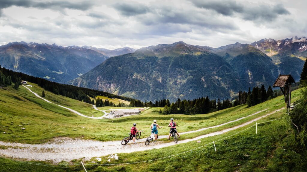
Tour #1: Trip to the local Mount Sattelkopf in two and a half hours. Arriving guests in St. Anton am Arlberg are usually quick to notice the Sattelkopf summit cross (1,985 metres) in the distance. It is, in fact, not that far away: the combined “(E-)Bike & Hike” tour to this Tyrolean village’s local mountain is particularly suitable for beginners and pleasure-lovers. Start in a westerly direction from St. Anton am Arlberg Information Office, towards the Rendlbahn cable car. Immediately after the pedestrian bridge, follow signs to “Moostalweg”, continue straight ahead until the second cattle gate and turn right at the next fork, where you head on to Tritschalm alpine farm for a break. A well-marked, not too challenging hiking trail follows in a north-westerly direction. After a relaxed kilometre, holidaymakers pass Tritscher Köpfl Peak, before finally reaching Sattelkopf Summit. The return journey may be along the same route, but with a 180-degree change of perspective. The mountain world of St. Anton am Arlberg can always be experienced from a different vantage point. Difficulty rating: moderate. 739 metres in elevation difference (bike 409 m/hike 330 m) Length: 17 kilometres (bike 11.4 km/hike 5.6 km). Total time approx. 5.5 hours (bike approx. 1:45 hours/hike 2:45 hours). maps.stantonamarlberg.com

Picture courtesy of: St. Anton am Arlberg Tourist Board/photographer Patrick Bätz
Tour #2: From Flirsch via Dawinalm to the “Großen See” (Great Lake). A wonderful combination of flowering alpine meadows, idyllic mountain lakes and regional Tyrolean specialities can be discovered on the easy to moderately difficult “(E-)Bike & Hike” tour from Flirsch, located around 12 kilometres east of St. Anton am Arlberg in the Austrian Stanzertal Valley. The tour starts at the local tourist office, from where bikers – either electrically powered or under their own steam – follow the main road through the Pardöll district and on to the turnoff towards Dawin. Continue along well-signposted forest paths to the eponymous alpine farm, from where the short hike below the Eisenspitze Peak begins It then takes around 15 minutes to reach this special source of spiritual power at Lake “Großen See“, where visitors can reward themselves with a scenic rest. The same route is taken for the return journey, alternatively bikers can cycle from Dawinalm via Schönverill back to Flirsch. Difficulty rating bike: moderate/ hike: easy. 1,040 metres in elevation difference (bike 960 m/hike 80 m) Length: 24.3 kilometres (bike 23.3 km/hike 1 km). Total time approx. 3 hours (bike approx. 2:30 hours/hike 0:30 hours). maps.stantonamarlberg.com
Tour #3: Via Rendlalm to the imposing Zwölferkopf Peak. Zwölferkopf Peak towers majestically over St. Anton am Arlberg at 2,558 metres above sea level, providing a mighty backdrop for summer guests to experience unique summiteering moments above the Austrian mountain village. 2,050 metres above sea level can be reached on two wheels, followed by a black-rated mountain trail, which is the section that classifies this route as a challenging “(E) Bike & Hike” tour. The route starts at St. Anton’s tourist information offices in the village centre. Follow the asphalted Stanzertal cycle path eastwards to the “Guhl” bend, where a turn-off leads in the direction of Alpe Rendl, from where you cycle uphill on the forest path along a pleasant incline. After a short rest at the picturesquely situated Rendlalm, the main part of the tour awaits alpine combination enthusiasts. While still in the saddle, cycle along the somewhat steeper northern flank of the Zwölferkopf to the parking area, just under 500 metres in altitude below the finish line. Now on foot, outdoor fans follow the signpost along a narrow path. Suitable footwear, sure-footedness, a head for heights and a sense of direction are required for the last stage, hiking poles are recommended. The route initially leads through the avalanche barriers. Soon, however, hikers will be moving steadily towards their destination on the western ridge of the Zwölferkopf. Patience is also required, as the summit cross only appears along the very last metres of the hike. Difficulty rating: moderate/ hike: challenging. 1,336 metres in elevation difference (bike 825 m/hike 511 m) Length: 23.4 kilometres (bike 20.2 km/hike 3.2 km). Total time approx. 4.5 hours (bike 2:10 hours/hike 2:30 hours). maps.stantonamarlberg.com
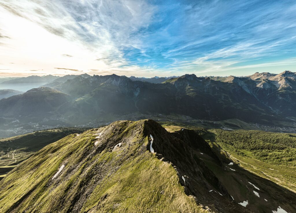
Picture courtesy of: St. Anton am Arlberg Tourist Board
Tip: The “inexhaustible mine of information” for holidays in St. Anton am Arlberg
It is a route planner, travel guide and source of inspiration all rolled into one: a digital mastermind for summer and winter holidays. As a central tool, it bundles and structures everything the region has to offer. The tourism association, guides and accommodation providers ensure that data is always up to date, enabling the map to provide detailed information on opening hours, closed hiking trails and slopes. Thanks to the involvement of the local community, it contains insider tips as well as personally tested, realistic walking and trip times for all tours. “The map already includes so much data in such high quality, it would be a real disadvantage for guests not to use it. And new information is being added all the time,” says Martin Ebster, Tourism Director of St. Anton am Arlberg. “The interactive map is an inexhaustible mine of information for anyone and everyone to plan and enjoy their holiday with us.”
maps.stantonamarlberg.com
About St. Anton am Arlberg. St. Anton am Arlberg is one of the world’s most prestigious winter sports resorts, with over 300 kilometres of exciting downhill runs and 200 kilometres of backcountry terrain. The Austrian holiday region also impresses in summer with various activities and sporting events against a spectacular Alpine backdrop. Gourmet holidaymakers appreciate the multiple award-winning cuisine in the tradition-conscious Tyrolean mountain village. Entente Florale awarded St. Anton am Arlberg with gold for its projects on quality of life, sustainability and environmental protection and named it “Europe’s most beautiful village in bloom.” In spring 2021, St. Anton am Arlberg was selected as an official Climate Change Adaptation Model Region. www.stantonamarlberg.com